


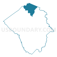
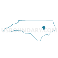
Voting District 0401, Pitt County, North Carolina
About
Outline

Summary
| Unique Area Identifier | 641179 |
| Name | Voting District 0401 |
| County | Pitt County |
| State | North Carolina |
| Area (square miles) | 41.62 |
| Land Area (square miles) | 41.62 |
| Water Area (square miles) | 0.00 |
| % of Land Area | 100.00 |
| % of Water Area | 0.00 |
| Latitude of the Internal Point | 35.77757570 |
| Longtitude of the Internal Point | -77.37069580 |
Maps

Graphs
Select a template below for downloading or customizing gragh for Voting District 0401, Pitt County, North Carolina


Neighbors
Neighoring Voting District (by Name) Neighboring Voting District on the Map
- Voting District 0201, Edgecombe County, NC
- Voting District 0301, Edgecombe County, NC
- Voting District 0301, Pitt County, NC
- Voting District 0501, Pitt County, NC
- Voting District R1, Martin County, NC
- Voting District R2, Martin County, NC
Top 10 Neighboring County Subdivision (by Population) Neighboring County Subdivision on the Map
- Belvoir township, Pitt County, NC (9,334)
- Robersonville township, Martin County, NC (3,451)
- Bethel township, Pitt County, NC (2,470)
- Carolina township, Pitt County, NC (2,070)
- Township 2, Lower Conetoe, Edgecombe County, NC (1,906)
- Township 3, Upper Conetoe, Edgecombe County, NC (736)
Top 10 Neighboring Place (by Population) Neighboring Place on the Map
Top 10 Neighboring Unified School District (by Population) Neighboring Unified School District on the Map
- Pitt County Schools, NC (168,148)
- Edgecombe County Schools, NC (45,606)
- Martin County Schools, NC (24,505)
Top 10 Neighboring State Legislative District Lower Chamber (by Population) Neighboring State Legislative District Lower Chamber on the Map
Top 10 Neighboring State Legislative District Upper Chamber (by Population) Neighboring State Legislative District Upper Chamber on the Map
Top 10 Neighboring 111th Congressional District (by Population) Neighboring 111th Congressional District on the Map
Top 10 Neighboring Census Tract (by Population) Neighboring Census Tract on the Map
- Census Tract 20.02, Pitt County, NC (5,246)
- Census Tract 208, Edgecombe County, NC (3,716)
- Census Tract 9706, Martin County, NC (3,302)
Top 10 Neighboring 5-Digit ZIP Code Tabulation Area (by Population) Neighboring 5-Digit ZIP Code Tabulation Area on the Map
- 27834, NC (52,914)
- 27886, NC (21,591)
- 27871, NC (4,619)
- 27812, NC (2,593)
- 27819, NC (330)
- 27861, NC (71)